More Clarity. More Confidence.
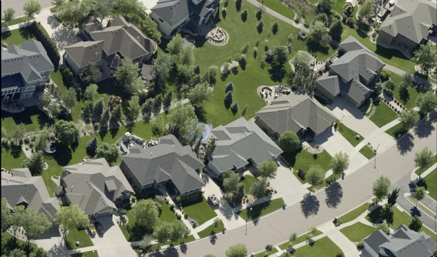
See the critical details you need with 1-Inch GSD imagery.
Ultra-High Resolution Imagery
See the Difference with 1-Inch Imagery
Ultra-high resolution imagery offering unprecedented detail.
Gain Greater Clarity to Go from Guessing to Knowing
Our 1-inch GSD imagery gives you 9x more detail than 3-inch imagery.
Gain greater clarity with incredibly detailed images that let you see and distinguish small infrastructure details.
Extract high accuracy measurements to ensure confident decision making.
Get a 360-degree view with both orthogonal and oblique side-angled views.
High quality data feeds machine learning models for improved data processing and efficiency.
See the Difference
Resolution Matters
The higher the resolution, the more detail to inform your decisions.
1-Inch GSD
The Clearest Imagery Available
Only available from Eagleview, this resolution captures incredibly high levels of details, offering a very fine-grained view from all cardinal directions.
3-Inch GSD
High Resolution Aerial Imagery
Very high-resolution aerial imagery that captures fine details, but lacks the clarity of sub 1-inch imagery.
6-Inch GSD
Standard Aerial Imagery
A standard resolution offering a broader, but detailed view of the real world.
Greater Accuracy for Multiple Needs
Property Assessment
Analyze granular construction details, building materials, grades, and other aspects to precisely assess the value of a property.
Urban Planning
Get the minute details needed to extract precise data for mapping, project planning, and urban planning.
Asset Management
See and distinguish small infrastructure details, such as signage, fire hydrants, and light poles, to better measure, track, verify, inspect and report on infrastructure components.
Public Safety
Get uncompromised clarity about incident locations, such as road access, door and window placements, rooftop load, and potential hazards.
“When I worked with 3-inch imagery, I was thrilled, but 1-inch imagery truly takes it to the next level.
1-inch takes us to where we can actually save money because people are spending less time in the field.”
“Our transportation and mobility team has been able to lay out sidewalks and bike paths using just imagery rather than engineers. With 1-inch imagery, we can determine if room exists for bike paths. Previously, we’d need surveyors. Saves money and time.”
“The 1-inch views let us gather important information on a home that we cannot see from ground view. We collect this data before going out into the field. With this, we can see and measure all levels of a home, roof type and roof materials just to name a few. This in turn saves our office valuable time.”
See the Difference
Get in touch to schedule a demo.
Customer Success
Douglas County: Improving Decision-Making & Cost-Efficiency with 1-Inch Imagery
Learn more